
|
|
|
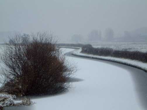
I went out on my own to prewalk my next walk for the Ramblers. The title is "Trevor's Time Walk". This simply means that it passes a couple of points of historical interest. I parked at the picnic site near Belmont Green (GR197265). The walk starts by going south-west down the road and picking up the footpath near Belmont Farm across to Blackbrook. Cross over the road and then walk south and then south woods, finally through woods, to Hanbury Park Gate. North wards on the track and then go straight through the riding stables at Hanbury Park (where I had to get tips from the owner on the footpath) and across the fields to the Crown at Hanbury Woodend. Then through Knightsfield Farm and across to the road folk at GR165273. Up to this point the walking was fairly uninteresting but relatively dry under foot and it was a pleasant sunny walk. Unfortunately the batteries were flat in my camera so I didn't get any photos (but at least I can have another go when I do the walk for real). At this point the whole character of the walk changed; it is very sudden too, provided that you haven't studied the map beforehand. The ground falls away steeply giving open views. This is the side of the Dove Valley. Not the popular walking section of Dovedale (although you can see the well-known part in the distance) but the lower Dove not far from its confluence with the Trent. It is a pleasant (if muddy) downhill section through Foxholes nearly into Draycott-in-the-Clay before turning back sharply up the hill into Hanbury. You can leave the public footpath to go up to the wonderful vantage point of Rough Hays. By this time I had picked up a way-marked walk. This is one of a series radiating out from the Hanchurch Hills picnic area. I've seen the County Council's leaflet on these but I hadn't actually used these to design the walk. However I did seem to be on one or other of them most of the way back to the car. I went through Hanbury Village and over to the Hanbury Hills. In there is a really spooky place, the Fauld Crater. This is about half a mile in diameter and 300 foot deep. It is the result of the largest ever explosion caused by conventional weapons. There was a munitions factory here in the last war and its store went off by accident killing 70 people (some of whom were not found afterwards). The crater was fenced off and left because of fears of unexploded bombs still being present. Some it has been reclaimed by the flora and is I suspect quite an haven for birds and small mammals. But it is very still and, as I said, quite spooky. It was a slight diversion to see the crater and I returned to the main path through the woodlands. Much of this is on a track without a lot of visibility but where it emerges is another stunning view. The jewel in its crown is the sight of Tutbury Castle which stands on the last section of the valley side guarding the Dove itself. Unfortunately the walk across to it is not as good as the prospect. It goes through industrial estate and exceedingly boggy fields where you have to work hard just to get your feet out of the mud. A great shame this; I'd been looking forward to walking these paths since the first time I saw the (when Beryl and I went to a craft fair at the castle on a lovely sunny day one May and watches lots of people strolling along the riverbank.) I doubled back at the castle (which is one of hose where Mary, Queen of Scots, was held prisoner and reputedly her least favourite) After recrossing the road from Tutbury to Fauld I immediately got back onto better paths up to Castle Hayes Park Farm and Hare Holes Farm before turning left and walking back down to the road and then to the car. About 12.5 miles including some diversions; the real walk will be about 11.75. it feels a lot longer however with the ground conditions. It was a lovely sunny day and, as Beryl was otherwise occupied, I popped out for a wander around the fields at home. It was quite a while since I had done this and it gave me a chance to play with my digital camera. It’s not classic scenery for photography as the fields are very open and usually lack a focal point but you can look at the results. I
walked out to Audmore loop and took the path up to the Hand & Cleaver pub at
Ranton Green. There were two women who saw me hop on to the initial stile and
they asked me about the footpath. Apparently they’d tried it recently and it
hadn’t been passable. Certainly one stile had collapsed since I last walked
the path and another was in the middle of a small lake – the natural pond next
to it had overflowed. Still I worked my way around it. I love the view down on
to the village from up on this path. Sadly my photograph doesn’t do it
justice. Turn left down the lane by the Cleaver and through Big Wood on to the Ranton Abbey estate. This is owned by the Earl of Lichfield and you always see lots of pheasants; the gun fodder of the coming year. Up the track nearly into Knightley and then back via Knightley Green and Moor End farms. I could have walked back down the lane from there but instead I took the footpath back to the Knightley road and into the village to take some more photos. I
wasn’t looking forward to the Ramblers walk on the Wrekin. We did it a couple
of years ago in poor weather and memories of that were putting me off. As it
turns out it was a lovely day. One of those winter days where the sun shines
brightly but without any real strength. They always seem to follow frosty nights
and today we were lucky in that much of the frost didn’t thaw and this saved
us from a number of patches of mud. We also reversed the walk compared to last
time and this, with the other differences in circumstances transformed the walk.
There was a good turn-out including a number of people I hadn’t seen in some
weeks. We
started at the main car park and skirted round the northern side of the Wrekin.
This meant that we climbed it o the western flank. This is much steeper and less
well-walked. I’d not been up that way before so it was a treat, even if it was
hard work. There is fortunately a natural stopping point at Little Hill where
you can start to enjoy the view. On to the top where I took my first group photo
with the new camera; I promise not to make a habit of this. We
had an early lunch just over the top and then came down much of the tourist
route (the Wrekin is apparently the most climbed Marilyn in England) Before we
got to the bottom we swung away westwards again and looped around into Limekiln
Woods. It meant that I took some good shots of the Wrekin in all its glory. There
is a way-marked route through here, the Hutchison Way (sorry, I have no details
on it) before cutting through the golf course. We then had to get over the
Ercall (pronounced Arkle) to get back to the car park. The legend is that the
devil set off with a shovelful of earth to bury Shrewsbury. He was tricked into
dropping this. The pile of earth from the shovel became the Wrekin and when he
kicked the earth off his boots it formed the Ercall. Well it was a climb that
seemed to go on and on but there are good views over Limekiln Woods. A steep descent and then back up the road to the cars. I
hadn’t expected to get out this week as Andrew & Alex were staying.
However Andrew had asked to go out so we compromised and went on the Ramblers
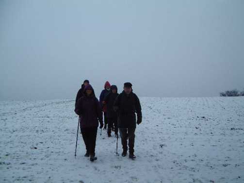
morning walk. Six miles around Berkswich led by Bob and Doreen Jenkins. Bob is a
local historian and so there was lots of interesting information around the
route. The other factor adding interest to the walk was that it snowed
overnight. Not as much as last month – most of it went during the course of
the day – but there was a covering of white. We
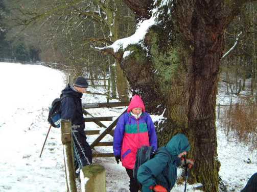
started at Walton village hall and walked down to the canal which
was frozen over. We followed the canal to
Milford. Over the road and up through Milford Covert. Then across the fields by
Cressel Wood into Walton-on-the-Hill; these were snowy and had a
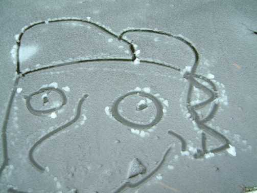
Siberian aspect. But we kept smiling. From Walton we took the fields to the A34, walked up it a bit before crossing and skirting around Wildwood to get back to the canal. It seemed a long way back along there; when I studied the map I saw that it is much longer than the distance by road. There was an interesting piece of grafitti, as someone had drawn a face in the ice on the canal. I
didn’t fancy the SRC walk around Ranton: I can do that from home at any time.
So I went off on my own. The walk linked two of my favourite tops in North
Staffordshire. I hadn’t done them as part of the same walk before although I
can remember seeing it some years ago as a route in Trail magazine. I
turned off the Leek-Buxton road at Upper Hulme and parked in one of the bays
right under the Roaches. The weather was really promising. There had been a
sharp frost overnight and at just after 9AM the sun was already out on the
Roaches and Hen Cloud. Gun was covered in mist but I reckoned that the sun would
soon burn that off. How wrong can you get? This was the best weather of the day.
Once I entered the mist as I set off up Gun I didn’t leave it for the rest of
the day. It wasn’t thick enough to cause a navigating problem but it meant
that I didn’t get any decent views off the tops. I
opted for the clockwise route. This was intended to leave the best – the ridge
of the Roaches – until last. It also meant that I would be crossing the
wettest section (the fields across to Meerbrook and the start of the climb out)
whilst the ground was still frozen. This was fairly straightforward to navigate
because it is so well waymarked; this is typical of the Staffordshire Moorlands
district. They have a very good network of footpaths. The best is the
Staffordshire Moorlands Walk (logo: a lapwing). This isn’t an end-to-end walk
so much as a quality standard. The paths on it are attractive to walk and
well-maintained. They offer all sorts of options for days out in this lovely
area. This
was the first time that I’d been up Gun from the Meerbrook site. It’s a long
pull but the initial path was reasonable dry up to Franklins where I picked up
my normal line of ascent on the rising path well marked by tractor prints. There
is an uphill section of road before you get on to the true moor (the entry point
is also the boundary of the Peak National Park. I like this bit of moor but,
covered in mist, it was not at its best. The same was true of the top of Gun.
This is Staffordshire’s only Marilyn and having this elevation the view from
the top is stunning on a good day. I actually think that it’s the best view in
Staffordshire (even though much of it is over Cheshire with the Cloud,
Shutlingsloe and Shining Tor prominent). You are also almost guaranteed having
it to yourself. However I didn’t get the view today so I didn’t linger for
too long. There
is a super descent from Gun to Turners Pool (a lovely spot in sunshine) and
round the back of Pool Farm but from there the route goes through a less
interesting phase. There is a climb through open wet fields to Old Springs and
then a section of road past a couple of entrances to Swythamley Hall. There was
a friendly kitten at Swythamley church. I stopped by the wall to stroke it
(I’d have a cat if Beryl is allergic to cat hair). Unfortunately it started
rubbing around my legs when I was trying to take a picture of the church; I took
an extra step back and trod right on its tail. That was the last I saw of it! I
turned up the footpath at the second entrance and climbed for a while before
dropping down into Danebridge. This was the start of the long pull up on to the
Roaches, which is a lovely line of ascent through woods but striking up to the
top at Hanging Rock (with a slight deviation from the proper footpath). This
then allows you to take in the whole of the ridge of the Roaches. It was a long
time since I had walked the entire
length, nearly 10 years I reckon.
It’s a long way along it and of course it wasn’t at its best. There was a
lot of walkers out on it and the climbers were out on the far end. I
didn’t take the normal descent to the climbers hut but carried on. The descent
of the end is a bit tricky. I thought about going up Hen Cloud but I was tired
and went straight back to the car. About
12 miles in total and a lovely walk. I think I’ll put in on the Ramblers
programme for the summer.
|
|
|