
|
|
|
Kidsgrove,
part of industrial North Staffordshire, on a grey morning was not the most
salubrious starting point for a walk. Town centre streets followed by railway
and canalside just added to the sense of gloom. One spot of industrial
archaeology interest; the start of the Harecastle canal tunnel. This is one of
the "leggit" tunnels of the West Midlands; the bargees used to lie on
their backs and "walk" along the tunnel roof to drive the barge
through the tunnel. This
was a Ramblers walk and as we walked out of town along the towpath the weather
and the scenery both got brighter and it was quite pleasant. But flat….we were
entering the Cheshire plain. After a couple of miles we left the towpath and set
out over fields and tracks to Little Moreton Hall. This is a gorgeous timbered
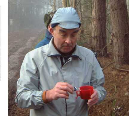
building now owned by the National Trust. We had coffee there (somewhat late at
11:50…much muttering in the ranks). There
was then a boggy section across fields cut up by cows. Still fairly flat. Then
came the big climb of the day, straight up Mow Cop. If the name isn't familiar
you might have seen it from the M6. It is
the hill with the curiously shaped folly on top, seen off to the left of the
motorway as you travel from Crewe to Stoke. It was a real pull up on to it, not
helped by slippery paths in the wooded section. We acquired a new member here. A
golden retriever appeared up at the head of the column and she went up just for
the fun off it. We kept expecting her owners to appear but they didn't. Then
after sitting with us for lunch she disappeared again. We
had lunch by the Old Man of Mow, a pillar of rock left behind by the quarry. The
National trust has acquired this too. Strangely the walk didn't take in the
folly; I nipped in to take photos and then caught up the rest as we dropped
steeply off the hill on the Cheshire side. More
muddy fields, one hill (again pleasantly in sunshine) and the return through
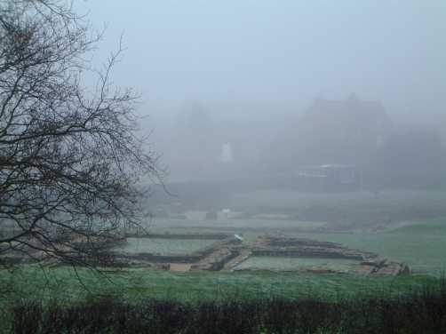
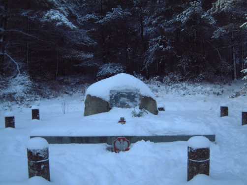
some back lanes into Kidsgrove. I went out on my own for the day and got some real satisfaction from a hard walk. Nearly 16 miles and it was worth more given the heavy (and in places far worse ground conditions), And no stiffness the following morning!! I started at Ellastone is the less popular part of the Dove Valley walking eastwards to Prestwood Lane. I cut across into the lower section of the Churnet Valley near Crumpwood Weir walking upstream to the Sprink. Then came the first hard climb of the day. Elsewhere on this site, I wax lyrical about my favourite estate. I was feeling a bit more benevolent towards their management policy as I entered by a couple of top quality styles. However it was soon back to the awful metal fencing and I had to get through one by way of their cage-like "stiles". I walked northwards along the ridge fom the Sprink and then crossed the road into Wootton Park. There are some glorious views up here although too much of the footpath has been turned into estate road for my taste. These took me ever upwards to Ramshorn. I went through Sycamore Farm to cross some very wet fields to the quarry below the Weaver Hills ridge (the passage being made worse by a brief downpour). I picked up the south-easterly path across Kevin quarry (although much of it was very well hidden) and this was enjoyable. However when the path dropped it became a total glue pot and the next half-mile took longer than it should have. A pleasant climb took me up to the trig station at the summit (371m). It's a commanding view on a fine day (which this wasn't; the wind had really blown up too). Along the ridge and then across the fields to Stanton. I picked up the line of a walk I once did for SRG to Cuckoocliff Wood below Ellishill. I tink that this is is spunky little hill especially viewed from the south. I looped around it, bright sunshine suddenly appearing so that it looked its best. Through Ellishill Farm where I was briefly disconcerted on finding a bovine with long horns blocking the path. It proved docile and I went on picking up the new extension to the Limestone Way to return to Ellastone. It had gone very dark and cheerless by then and the path was boggy. I cannot remember getting quite so filthy on a walk for a long time. It was one of those days when you realise that you are out there just for the exercise and the company rather than the views and the splendour of the scenery. We walked a circuit around Lichfield which was flat and misty. Plus points were the lack of stiles and amazingly dry soil which made for quick walking. One common factor between flat and dry was the red sandstone rock base. We left southwards on the Heart of England Way (from which regular readers will realise that the leader was Ron). This took us through the shopping centre, housing estates and a section of the Tamworth road before we reached a proper footpath across some open fields. More road walking around Swinfen before stopping for a drink in some woods. Ron demonstrated his tea-making skills; he's such an infuse-iast. I can't remember a lot about the next section to Wall; a mixture of fields and roads. We did stop there to get a view (over the back hedge) at the Roman remains (Letocetum) It's a place where I'd long felt I should go but never had. Others in the group knew nothing at all about it. We had lunch there. We headed northwards from there and rejoined the Heart of England Way near Chorley. Pleasant stroll back along it into Lichfield, detouring past the cathedral and doing a quick bit of Christmas shopping before returning to the car. An SRG morning walk from Val Milne's house at Whiston. Not a good morning - Beryl backed out at the last minute as she had a cold and didn't want it gett8ing worse for Christmas - but he rain stopped just as we set off. It wasn't a very long walk but OK given Christmas commitments and very wet terrain; it also gave us the chance to have mince pies and sherry after the walk. The route went southwards out of Whiston and then across the fields to Bickford Grange farm. Back up the road a bit and then almost all the rest was on the Staffordshire Way via Mitton until we cut off back into Whiston. I was quite surprised to see the Staffordshire Way. I thought that we were still north of Penkridge and I knew that the way runs westwards from there before turning south again. It snowed overnight so Beryl and I went out on the Chase for a short amble. The world and its partner (note the non-gender, non-orientation, non-religion specific terminology) had the same idea and we slithered round several icey car parks before finding a space at Chase Road Corner. We followed the Heart of England Way briefly back towards its starting point on Milford Common before dropping down into the Sherbrook Valley. Climbed out near the head of the valley before following a somewhat indirect route back to the Katyn Memorial; this commemorates a WW2 massacre in Poland; note the Polish White Eagle on the photo. Then a pleasant stroll back in the sun along the Heart of England Way again back to the car. We went out for the day with Bob and Maxine. The original plan was to go up Brown Clee. However with all the snow about we opted to travel by better roads and headed for Church Stretton. We found a lay-by on the main road which was a handy starting point for Caer Caradoc. I walked this path up Caradoc some years ago with Andrew and Beryl and I had done much of the walk with SRG in the summer; but it was totally different in snow and on a very clear day. We didn't walk particularly quickly (not quite 8 miles in 5.5 hours) but it was a super day. I took lots of photographs. It's a good hard pull up Caradoc but it's well worth it. The panorama of the Shropshire Hills is superb with the view across the Stretton Valley to the Long Mynd a delight. You can pick out all the lovely deep valleys which are the particular joy of walking there. The wind was also pretty icey so we dropped off a bit before having coffee. The plan was then to take the long sweeping descent to avoid problems with slippery slopes. This didn't quite work as planned as the final section was fairly steep and had the adhesive qualities of greased glass. We climbed over the col to the west of Hope Bowdler Hill and then looped right around it, through Hope Bowdler village and finally reaching the summit at nearly 3 o'clock. This time we had a chance to study Caradog across the divide. Then a steady walk back to the car, doing well I found to find one secretive footbridge.
|
|
|