
|
|
|
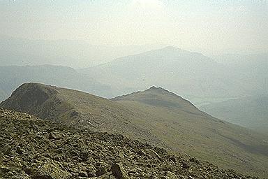
1 April This was one of Reg's Ramblers weekends. This is a sub-group of both SRG and the Mid-Staffordshire Ramblers organised by Reg Dear. The weekend was based at Conniston. Most of the others went up on Friday but Beryl can't get the time off school so we travelled on Saturday morning. Having said this I went off on my own on Saturday whilst the others climbed Dow Crag and the Old Man. I was doing unashamed Wainwright-bagging; this applies when I do scattered hills and take the car between them. I'd been somewhat indecisive about whether to have a day on my own. In the end I decided that it came down to the weather. The forecast on Friday night was bad; dull and rainy over the whole country which I reckoned meant "truly vile" for the Lakes. We were delighted on arrival to find it dry and clear and looking set like that for the day. It was a case of going for it! My first objective was Cold Pike. The easy route involved parking at the Three Shires Stone on the Wrynose Pass and thus only having 1000 foot of climb. I'd worked from Pike o' Blisco to the Crinkle Crags before in my pre-peak-bagging days and missed Cold Pike when it would have been very easy to take in. I therefore reckoned that I had a rain check on the climb from Great Langdale and could take this easier route legitimately. It's a pleasant walk up and an interesting, rocky top when you get there. Good views all round and the top to myself. Bliss! Back to the car and over to Eskdale. This meant crossing the Wrynose and Hard Knott passes, a new experience for me. You need to keep your wits about you. I parked at Wha House and went up Slightside. The path is very straight forward but very untypical of the Lakes; almost like Wales. The Eskdale panorama was suberb. I've not had a look of luck in the past in getting views over this valley. If I had to vote for my favourite lakeland valley. I'd have to plump for Buttermere\Crummockwater but Eskdale probably comes out second. Slightside looks like it real peak from this angle; it is only an outlier of Scafell but the true summit was hidden behind Slightside. Its top is another rocky delight. I had been unsure why Wainwright included it but I'm convinced now. Slightside from above looking to Eskdale (Photo: J Dawson) Another car trip back to the top of Hard Knott pass and a relatively short and easy climb up Hard Knott. Probably the least interesting top of the day but again I had it to myself. I ought to return here because the most interesting bits seem to be on the harder route from the old Roman fort. So why this eclectic set of hills. They were three of my final four Wainwrights. I'm now set up for Harter Fell on 1 May.
2 April "This is probably the easiest walk that you've ever done with me," said Reg at the start of the day. "About 9 miles and pretty flat" There were those who begged to differ by the end of the day; I measured it at 12.5 miles with my wheel. It was a leisurely start down Connistonwater (not my favourite lake by some way) along the Cumbria Way. Then we climbed up behind Goat Hill into a relatively unwalked area which I found the most attractive of the day. Back over the Torver Commons and return along the Lakeside again. A pleasant day and not desperately strenuous but a bit more than a 9 mile pootle, Reg! I really ought to say that, having slated the Lakeland weather so much in this diary, we were very lucky his weekend. The rest of the country fared much worse. We seem to have benefitted from high pressure between two weather systems.
The SRG walk led by Angie and Chris which started out from Winster, Derbyshire. A very enjoyable day mainly on new ground; I had walked around Winster on 3 previous occasions but the route was over to the south and east of the village. The weather got better and better through the day (having promised to be really wet as we were driving over) We went down Wensleydale through Clough Wood to the edge of Darley Bridge before cutting across to Wensley itself and thn Snitterton. There was a big climb of nearly 600 ft up through Jughole Wood (I stopped to have a look at the cave but no opne else did). We dropped down again into Bonsall (a very pretty village) and had lunch by the children's playground. Another climb up through Uppertown and heading on th high ground towards Ible. However we turned back northwards before getting to the village and so kept to the high ground. This was all easy walking so that we made good time. Back to Winster via Win Tor.
Beryl and I on holiday in Majorca. We were staying at Puerto Pollensa on the northern coast. Whilst we'd booked four days of guided walks, we'd decided to do our own thing on the first day. Having borrowed books, talked to others who had walked there and taken account of other commitments and bus time-tables, we decided to walk on the Formentor peninsula. The bus ride is only a couple of stops but, for spectacular roads and coastal scenery, it was well worth the 75p each. We got off at Formentor beach, near to the Formentor Hotel (resting place of the rich and famous on the island). I was following a walk from a book. It was very strange not having a map! We picked up the first track easily enough but missed a turn-off. When we got back to it there was a No Entry sign (in four languages so we had no excuse for ignoring it). However various people had told us that you take no notice of such signs so we continued. The book said that the path soon disappeared and gave vague directions for picking up a better path. These were not easy to follow on the ground and it was very rough under foot; a mix of rock and scrub. Nevertheless we were climbing and getting better views of the shoreline. The sea was a gorgeous shade of blue. It took the best part of an hour but we made it to the better path. It was much easier there and the way was marked with cairns. We were climbing but not severely and this was the best bit of the walk. Formentor is a complicated coastline and as we climbed it was gradually revealed to us; absolutely beautiful. There was also a lovely breeze warding off the heat of the day. We were on a hill called Na Blanca; I suppose that means the White Hill (or Stobhan or Rhiw Wen, if you prefer). Just over 1000 ft and a super view all round. It was much windier on top, which Beryl didn't like, so that we didn't tarry for too long. The descent followed a ridge which was again well-cairned until it reached a track. This meant and easy walk down to the valley and then for a couple of miles through pine woods back to the bus stop (climbing a fence at the end which also had No Entry signs) That evening we spoke to the guides for the organised walks. They were not surprised that we hadn't seen a soul all day. The entire peninsula is off-limits to walkers and we'd been lucky not to be turfed off by patrols. The land is own by the hotel and they decided to exclude walkers about 3 years ago. This is a great shame; it is a lovely walking area and a superb introduction to the island. It doesn't seen to be much used by the hotel guests either; what a waste! Still there is a part of me which feels enormous pleasure for having done the walk, more so than if there had been open access.
19 April The first organised walk of our trip. It was slightly the easier walk of the two on offer but it ended a Deia. Beryl had been told that this was a pretty village and well worth the visit. It was quite a long coach trip to get to the start in Soller, even though the time has been much reduced by a newish tunnel (3 km through the mountain). There was a long pull out of the Soller Valley with a short stop near the top for freshly-pressed orange juice (a local cottage industry). A lot of the walk was on cobbled path and at the tops of the terraces containing olives, figs, oranges and lemons. Gradually we turned a corner and got views of the coastline. We dropped down to the edge of the sea for a lovely section through light woodland. There was a stop on the beach at Cala Deia before a half hour climb up into the village itself. Tijme there for a quick drink (the thought of which helped several of us during the climb). Beryl and I carried on to the hilltop above the village where the church is. Robert Graves is buried there but we couldn't find the grave. Still it is a lovely viewpoint. The walk was about 9 mile and it had been quite hard for no obvious reason (other than it was a bit muggy). However on the return journey we were told that it had been the hottest day of the walking season and this must have had some effect
20 April A fairly similar walk to the previous day starting on the opposite side of the Soller Valley but much higher up. We contoured around for some way (spotting a black vulture en route) and then dropped down to an isolated farm for an orange-juice stop before the big climb off the day. About 20 minutes of hard work up to a col for lunch (with a good view down the coast running north-eastwards away from Soller) We spent much of the afternoon on a high level coastal path. This should have been easy going but the amount of stone underfoot meant that it wasn't as relaxing to walk as it might have been. There were plenty of people along the path (and all the nice rocky outcrops seemed to be occupied by Germans). We reached Tuent where Beryl and I didn't hang around at the bar; we preferred the option of a paddle down at the cove. The bus was waiting there and there is a spectacular climb out up a road called Sa Colobra (the snake) which as you can imagine winds about just a little.
21 April The hard walk of the week! The highest mountain on Majorca is the Puig Mayor; this is owned by the military who have a radar station on top and walkers are excluded from most of the mountain. The highest accessible peak is Massanella which is on the walk programme for the opposite week. However the guides reckon that the walk on the l'Ofre ridge is the hardest that they do. I'd certainly agree that it is the hardest 6 mile walk that I've ever done but this was probably influenced by the temperature being nearly 80° F. The walk is very simple to describe. Start by the Cuber reservoir. Take the track to the dam and turn off down the gorge for a little way. Then a long, long pull up Sa Rateta (1084m). The views from the stop are stunning, looking across the reservoir at Puig Mayor. It is not far before the ridge drops steeply before another pull of c400ft up on to the Puig de na Franquesa (1067m) Then down again before climbing l'Ofre (1091m). We were promised that this was the easiest climb of the three even though it is the highest peak. I'm not convinced. It is a very distinctive triangular peak with trees nearly up to the summit; it is easy to pick out from the plain in the south and centre of the island. It was quite busy at the top; prior to that we hadn't seen anyone on the walk. A long drop down and then a good two miles back along the track. We'd made very good time over the day and were looking back to getting back fairly early to Puerto Pollensa. Ah the best laid plans etc; there was a cock-up with the coach driver who was waiting for us in Soller and so it was an hour and a half before he realised this and got up the mountain to meet us.
22 April Day off the official walking programme. We took the bus to the nature reserve at Albufera and did a bit of bird watching. However we felt like total amateurs compared to the real twitchers there. We did enjoy the herons and egrets though.
23 April Rain and cloud on the Puig Roig; almost like being in Wales (and after the relentless heat of the previous days it was very enjoyable) The walk was one of the classics of Majorca, the circuit of the Puig. This is only accessible on a Sunday because one section is across private land and the farmer closes the access off for the rest of the week. This means it can get busy and as it was Easter Sunday (not to say St George's Day which gave me an excuse for some xenophobia, especially about the Celts) so we set off early. The start was fine if dull but we soon climbed into cloud and the rain started shortly after. It lasted for about 30 mins but it was dull for much longer. This section was overlooking the coast; the sea wasn't the vibrant colour that it had been. Still the weather improved and the sun eventually came out without being excessively hot. We had lunch by some cave houses overlooking the Puig Mayor (again; it really does dominate the surrounding area). A long descent down track before a final climb of the holiday to the monastery at Lluc. We'd time for a look round; the thing that fascinated me was finding a lift in a very old cloisters; it just seemed so out-of-place. The monastery is a tourist attraction and was heaving with people. Verdict on the Week: A good holiday. Interesting new terrain. Not walkable in the Summer because it is too hot.
30 April Beryl and I overnighting in Eskdale. Having travelled up on Sunday morning we did a little walk on Muncaster Fell. This is not terribly high at 231 metres but it is a Marilyn. More than that this was a super walk on a lovely sunny day. We parked in the lay-by near the river just before reaching Eskdale Green. The first section was following a track alongside the fell which started climbing steeply after 2-3 miles and then turned back on itself to strike up to the summit. Despite the lack of height it did give a wonderful panorama of England's highest hills; a great sweep from Conniston through the head of Eskdale and round through Seatallen and the far Wasdale fells. I could also see land looking out to sea. It was too close for the Isle of Man so I'm guessing that it was the Mull of Galloway. The views were simply stunning. We returned along the top of the fell. Now this was very busy but most of the traffic was coming towards us. I couldn't understanding this; they'd be looking into the gradually rising hill with views to the side only. We however had magnificent views straight up Eskdale as well as the sides. We even saw up Miterdale which is something of a lost valley; we walked there a couple of years ago when walking with Reg's Ramblers on a weekend of indifferent weather in Eskdale. It was Harter Fell that dominated the scene for me. This was my final Wainwright scheduled for completion on the following day. If only this weather could keep up. We got to the end of the fell quite early and had a long stop before the final descent (and a nap!!). There were various ways back to the car but I wanted to see something of the Eskdale Light Railway so we tacked across towards Eskdale Green. Almost straight away we saw a family out walking with their dog but they also had a couple of cats following; more of them later. Back through the village catching sight of a couple of trains on the railway. We then had to find the guest house (Forest How) where we were staying. This was at the end of a long lane and studying the maps we realised that, during the walk, we'd turned off a track about 50 yards short of the house. This was confirmed whilst having a cup of tea in the garden; two cats appeared and I recognised them as being the two that we'd seen following the family (typically I'd not recognised the dog!). The guest house was super; thoroughly recommended. We also had a pleasant evening with two other couples chewing the fat about walking holidays.
|
|
|